Geopandas and Pandas Alive
Posted by Jack McKew on Fri 12 June 2020 in Python • Tagged with python, visualisation • 6 min read
Geopandas and Pandas_Alive
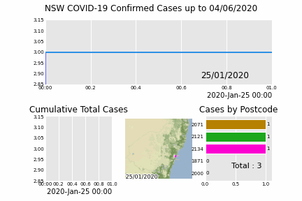
Following on from a previous post on making animated charts with pandas_alive, let's go into generating animated charts specifically for geospatial data with geopandas. Support for geopandas was introduced into pandas_alive in version 0.2.0, along with functionality to interface with contextily for enabling basemaps. The …
Continue reading